Repairing Long-Past Damages to Ashworth Creek

Article by Doug Norton
Fairview Town Crier
Article at https://fairviewtowncrier.com/wp-content/uploads/2023/12/Crier_12_23-Online.pdf (pages 16 & 17)
Or at Repairing Long-Past Damages to Ashwork Creek

Check out this amazing article about stream restoration on Ashworth Creek. The project was initiated by Flying Cloud Farm (owners Annie and Isaiah Perkinson) and area landowners, including the Lynch and Hamilton families. Key partners included Resource Institute, USDA, the State of North Carolina, Buncombe County Soil and Water, Jennings Environmental, and North State Environmental.

Building a Home for Hellbenders on Hog Lot Branch & Bates Branch Restoration

Resource Institute and partners restored and stabilized a reaches of Hog Lot Branch and Bates Branch near Franklin, North Carolina.

Franklin, North Carolina

Are hellbenders in a stream near you?  Resource Institute recently completed a stream restoration project on Hog Lot Branch and Bates Branch near Franklin, North Carolina.  Both reaches of the stream were severely eroding, and agriculture production was impacted.  The project team restored 1,250  feet of stream, which included stabilizing the creek and streambanks and creating habitat for a variety of species, including hellbenders, which were last sighted in Bates Branch in 2003.

A hellbender taking refuge under a rock.

The hellbender, the largest salamander in North America, is native to the eastern and central United States. They typically live under large rocks or boulders partially buried in cold, fast-flowing streams. These rocks provide protection from predators, and hellbenders may abandon a habitat if the rocks are removed or disturbed. (National Wildlife Federation

Morgan Harris, a biologist with the Southeastern Hellbender Conservation Initiative and the Conservation Management Institute at Virginia Tech, assess Bates Branch for hellbenders and hellbender habitat.

When the project began, the team consulted with Morgan Harris, a biologist with the Southeastern Hellbender Conservation Initiative and the Conservation Management Institute at Virginia Tech.  Harris worked with engineers at Michael Baker International to incorporate hellbender habitat into the restoration plans.

The project team rebuilt the channel with meandering bends and installed instream rock and toe wood structures.  To encourage hellbenders, the team added big flat rocks that are slightly elevated from the bottom so that there is a large enough cavity to lay and guard eggs as well as make a home in and around the rock clusters. Lastly, the team established a wooded riparian buffer along both sides of the stream. Alan Walker, Resource Institute, says, “The riparian buffer is critical for all aquatic species on Hog Lot and Bates Branch from macroinvertebrates on up, including hellbenders.”

Eroding streambanks on Bates Branch prior to restoration.

The project assessment, design, and construction required a team with a diverse set of skills and experience.  Resource Institute managed the project, leveraging funding from the NC Department of Water Resources, NC Land Water & Fund, and NRCS, Macon Soil & Water Conservation District worked locally with the landowners, Michael Baker International designed the restoration plans, and Penland Contracting constructed the project with Belflower Construction performing the riparian planting.

Resource Institute and the Macon Soil & Water Conservation District are currently working to identify new sites for restoration.  Harris says, “Macon County restoration projects are critical. Little Tennessee south of Franklin is really in bad shape; any restoration will keep a lot of species alive. Protecting these tributaries is genuinely important.”

The project team planted 460 trees and 2,500 live stakes and shrubs.  The plantings will enhance aquatic and wildlife habitat and aid streambank stabilization.  The riparian planting will also contribute to carbon sequestration.  Over ten years, the plantings will sequester 23 tons of carbon.  Overall, the project will reduce sediment in the stream by 75 tons per year.

Restoration Improves the Mitchell River from Hurricane Michael Devastation

Resource Institute and partners restored and stabilized a section of the Mitchell River near the old Kapps Mill Dam. Hurricane Michael devastated the region and cause the old Mill Dam to blow out.

Mountain Park, Surry County, North Carolina

A stream restoration project on the Mitchell River is currently under construction.  In October 2018, Hurricane Michael inundated Surry County dropping more than 10 inches of rain in some areas.  This torrent of rain blew out the historic Kapps Mill dam along the Mitchell.  After the blowout, the stream was flooded with tons of fine, sandy sediment causing extensive erosion and impairing water quality.

Surry County consulted with Resource Institute to find a solution.  Surry County and Resource Institute have a strong history of restoring reaches of the Yadkin River watershed.  Resource Institute is a nonprofit based in Winston-Salem and specializes in stream restoration.  In all, Surry County and Resource Institute have completed 36 river restoration projects restoring and enhancing almost 28 miles of stream in the county.

After meeting with the county and several landowners, Resource Institute partnered with Ecosystem Planning & Restoration (EPR) to assess the situation.  The partners found that the Kapps Mill breach released tons of fine sandy sediment stored behind the dam.  The stream was trying to reestablish access to its floodplain, causing severe erosion along its streambanks.  In some areas, the banks were more than 10 feet high, and in other areas, the stream was cutting into the state road.

Additionally, this section of the Mitchell River is home to a population of Brook Floaters (Alasmidonta varicosa), a species of freshwater mussels.  Brook Floaters prefer gravel riffles in well-oxygenated, free-flowing streams. There are only 14 known populations of the Brook Floater in North Carolina (Brook Floater Conservation Plan for North Carolina 2020).  This population was at risk because of the excess sediment from the dam.  Brook Floaters are not very mobile, and the fine sands from the dam covered their habit and impacted the mussel’s ability to get oxygen and find food.

Resource Institute realigned a section of the Mitchell River and rebuilt the floodplain. The restoration approach uses bioengineering and instream structures to stabilize the streambanks.

With all this in mind, EPR produced design and engineering plans to repair and restore the stream.  EPR and Resource Institute use sustainable river engineering technologies based on the “natural channel design” approach to improve the natural stream stability and habitat functions.  The plans call for a channel realignment and rebuilding the floodplain.  The restoration approach will also use bioengineering and instream structures to stabilize the streambanks. 

Currently, North State Environmental is constructing the restoration project.  In all, the project will repair and restore 1,500 feet of stream.  In-stream construction will be complete in the next few weeks.  Early this winter, the project team will return to complete riparian planting.  The team anticipates planting 550 trees and 1,650 live stakes and shrubs.  The plantings will enhance aquatic and wildlife habitat, also helping to stabilize the streambanks.  The riparian planting will also contribute to carbon sequestration.  Over ten years, the plantings will sequester 22 tons of carbon. 


North Carolina Division of Environmental Quality provided funding for the project.  After construction, the landowners, community, and visitors will experience many benefits.  The sediment reduction will enhance the water quality in the region – protecting drinking water, fishing, paddling, and other recreation opportunities.  The community will benefit economically from recreational users, reduce water treatment costs, and improve the river’s capacity to handle large storm flows.

Charles Anderson, Resource Institute, says, “The Mitchell River is an outstanding water resource.  The water quality is spectacular, and the recreational opportunities are tremendous, particularly fishing and paddling.  It is important to restore this stretch of the river before the water quality is lowered enough to affect the Brook Floater and other aquatic life. Also, the severe erosion was impacting local landowners.  The potential for severe flooding during another big storm was high.  This project not only improves water quality, but it also boosts flood resiliency.”

By Paula Worden, Resource Institute
Peer-Reviewed by Ashley Hawkins, Alan Walker & Squeak Smith

Restoration Work Cleans Up Mitchell River’s Hurricane Michael Damage

A Mitchell River watershed-restoration project has improved water quality and repaired damage from 2018's Hurricane Michael, as well as restoring habitat for trout and freshwater mussels. The hurricane caused the river to choke up with tons of fine, sandy sediment. Darrell Westmoreland, chief executive of North State Environmental, who led the project construction along with Resource Institute, said that caused extensive erosion that also affected local landowners.

Elkin & Surry County Unify to Improve Community Water Supply

Resource Institute and partners rebuilt Big Elkin Creek's channel and stabilized the stream. The restoration project will reduce sediment going into the Town of Elkin's water supply.

Resource Institute and partners rebuilt Big Elkin Creek's channel and stabilized the stream. The restoration project will reduce sediment going into the Town of Elkin's water supply.

Elkin, Surry County, North Carolina

Resource Institute, the Town of Elkin, Surry County, and Watershed NOW recently completed construction on a significant stream restoration project on Big Elkin Creek.  The project stabilized 3,500 feet of stream, protects Elkin's water supply, and improves the water quality of Big Elkin Creek.


In the early 1900s, Duke Power built a hydroelectric dam on Big Elkin Creek above Carter Falls.  Duke Energy decommissioned the dam in the 1960s. However, the removal left a lake remnant/pool filled with fine sediment.  The sediment worked its way downstream, eating away at the streambanks and creating an incised channel with no access to a floodplain. Hurricanes Michael & Florence exacerbated the situation in 2018, causing additional erosion. Sixty years of this battering caused severe instability and steep unstable streambanks. Big Elkin Creek was moving thousands of tons of excess sediment each year.  The Creek supplies water to the Town of Elkin and communities in eastern Wilkes County.  The high sediment load often forced the Town to shut off water intakes during significant storm events.  

North State Environmental constructed a new channel, rebuilt the floodplain, and restored Big Elkin Creek's natural pools, riffles, and runs.  North State also installed several instream structures made of rock and wood to protect the streambanks

North State Environmental constructed a new channel, rebuilt the floodplain, and restored Big Elkin Creek's natural pools, riffles, and runs.  North State also installed several instream structures made of rock and wood to protect the streambanks

The Town of Elkin faced several problems.  There were concerns about the water supply, sediment inundation in the town park, library, and school ball fields, plus the possibility of future inundation. Local landowners were especially concerned about the significant erosion of their streambanks.  In 2018, the Elkin Valley Trails Association (EVTA) was building trails along the Creek, including a segment of the Mountains-to-Sea Trail. The increased sediment in the Creek was detrimental to aquatic species and wildlife and the enjoyment of hikers on the trail. The EVTA was especially concerned because it planned to construct a bridge across Big Elkin Creek just below the Carter Falls.  These groups consulted with Watershed NOW, a nonprofit that protects and preserves the Big Elkin Creek Watershed. Watershed NOW consulted with Dick Everhart, a stream restoration expert working with the nonprofit Resource Institute.  Headquartered in Winston-Salem, Resource Institute restores streams, rivers, and wetlands

Big Elkin Creek was moving thousands of tons of excess sediment each year.  The Creek supplies water to the Town of Elkin and communities in eastern Wilkes County.  The high sediment load often forced the Town to shut off water intakes dur…

Big Elkin Creek was moving thousands of tons of excess sediment each year.  The Creek supplies water to the Town of Elkin and communities in eastern Wilkes County.  The high sediment load often forced the Town to shut off water intakes during significant storm events.  

Everhart said the key to making this project happen was working directly with the landowners. "We went directly to the landowners.  We talked about the problems and what could be done to fix them.  We also gave them the opportunity to see similar stream restoration projects in Surry County."

Resource Institute brought in Ecosystem Planning & Restoration (EPR), a design firm familiar with stream restoration methods, to help find a solution.  The project team assessed the area between the old dam and Carter Falls. EPR produced design and engineering plans to rebuild the channel, stabilize the stream and reduce sediment.  Construction of the project began this spring.  North State Environmental constructed a new channel, rebuilt the floodplain, and created a more natural pattern of pools, riffles, and runs.  North State also installed several instream structures made of rock and wood to protect the streambanks.  The next step in the restoration process is to plant trees and other live stakes this winter.  These plants will also help protect the banks and create fish and wildlife habitat along the riparian corridor.

The community was also instrumental in this project.  Woody Faulk of Watershed NOW said he's proud of the community and project partners. "We have a diverse community with lots of different viewpoints.  But everyone came together on this project for the good of the community. There is increased awareness of the need to protect the water quality of Big Elkin Creek, the lifeblood of our community."

Landowners, citizens, and visitors to the community will see an abundance of benefits from the restoration.  Reduced sediment in Big Elkin Creek will improve water quality and boost flood resiliency.  The project will also enhance fish and wildlife habitat creating recreation opportunities. Recently, the state of North Carolina acquired Carter Falls and surrounding property.  Segment six of the Mountains-to-Sea Trail runs through the property.  This segment connects Pilot Mountain State Park to Stone Mountain State Park. The project will play into the community's goal to increase tourism and bolster the local economy.  Hikers can access Carter Falls at the Carter Falls Trail Head near Byrd's Branch Campground.  The North Carolina Department of Environmental Quality funded the Big Elkin Creek restoration project.

By Resource Institute’s Technical Writing Team - Paula Worden, Alan Walker & Squeak Smith.

NC Community Tackles Erosion, Sediment Issues in Water Supply

Resource Institute and partners recently restored a portion of Big Elkin Creek in Surry and Wilkes County to improve habitat and downstream water quality.

Resource Institute and partners recently restored a portion of Big Elkin Creek in Surry and Wilkes County to improve habitat and downstream water quality.

Audio Block
Double-click here to upload or link to a .mp3. Learn more

ELKIN, N.C. -- Surry and Wilkes County residents will have cleaner water with less pollution and less sediment, thanks to a recently completed stream restoration project led by Resource Institute.

Hurricanes Michael and Florence in 2018 exacerbated the region's erosion and sediment problems.

Richard Everhart, consultant at the Resource Institute, said high sediment levels previously forced the town of Elkin to shut off water intakes to its reservoir during significant storm events.

"And again, with any kind of heavy rain event, it's obvious that the watershed's not in that great of shape," Everhart observed. "A lot of sediment, water that should be running clear, runs red, so there were a lot of different issues."

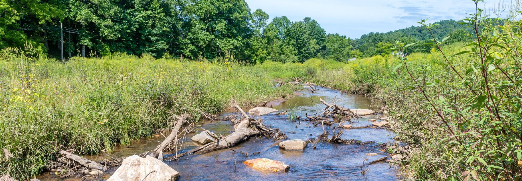
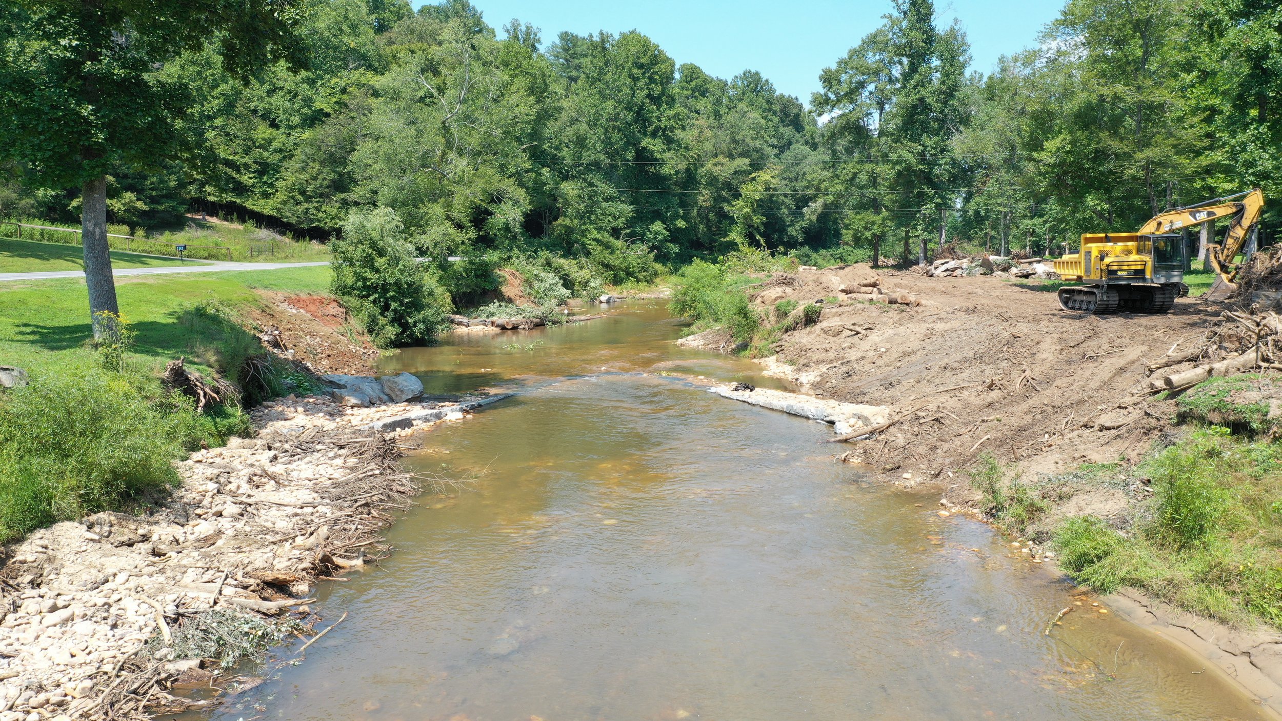
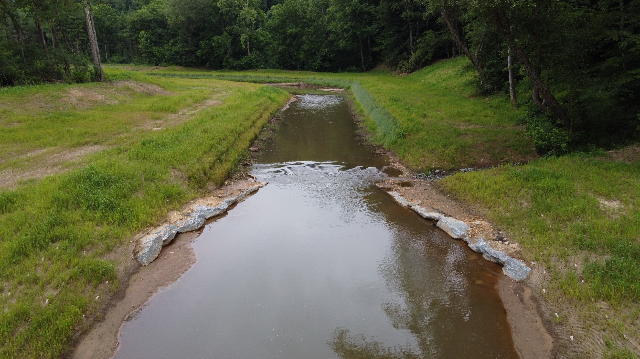
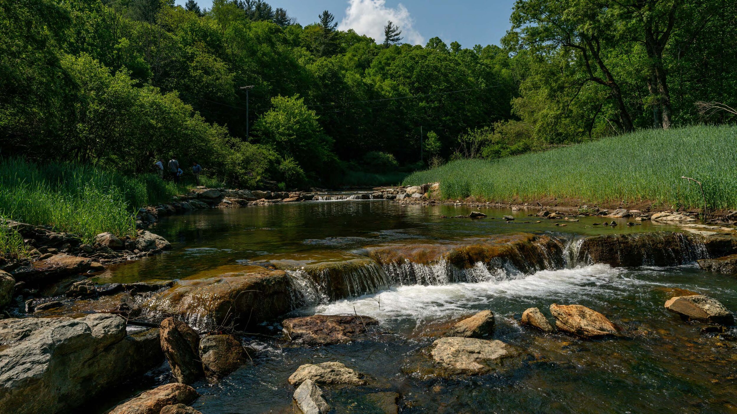
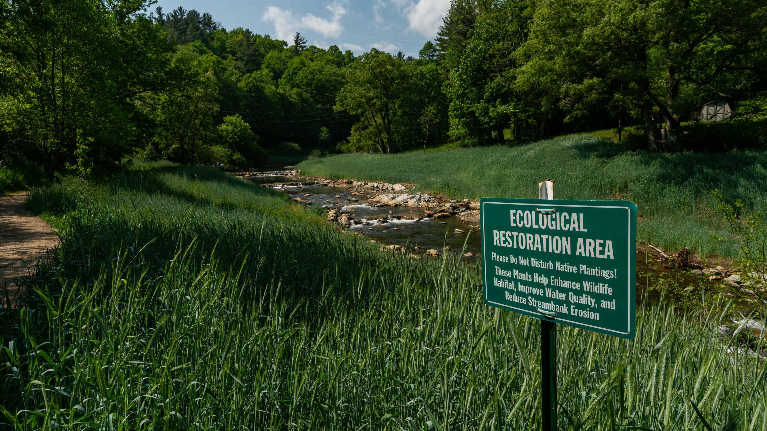
The project stabilized 3,500 feet of stream, and reduced sediment load in the Creek. Engineers restored Big Elkin Creek's natural pattern of pools, riffles, and runs, and protected stream banks with structures made of rock and wood.

Everhart pointed out trees will be planted to help protect the banks and create wildlife habitat and added the project will boost flood resiliency and enhance opportunities for outdoor recreation.

"Landowners, groups, local government, they all need to reach out and understand there are opportunities out there to address these kinds of problems, even sometimes when they're as large as this one and look as daunting as this one," Everhart explained. "The resources are there, and the work can be done."

Jake Byers, senior water resources engineer for Ecosystem Planning and Restoration, said stream restoration costs can be significant, but the long-term benefits pay for themselves.

"The landowners themselves are continuing to lose land from bank erosion," Byers noted. "Land that they're still paying taxes on that doesn't necessarily exist because it's been washed down the stream."

In addition to the Resource Institute, the project was completed by the Town of Elkin, Surry County, Watershed NOW, and North State Environmental.

Nadia Ramlagan, Producer, North Carolina Public News Service

Original Article at https://www.publicnewsservice.org/2021-07-29/water/nc-community-tackles-erosion-sediment-issues-in-water-supply/a75155-1

Payne Branch Project Comes to Fruition

After the dam was removed, instream structures were installed in the new channel. The structures will create and enhance aquatic habitat and restore the natural water flow of Payne Branch.

After the dam was removed, instream structures were installed in the new channel. The structures will create and enhance aquatic habitat and restore the natural water flow of Payne Branch.

Boone, NC

An unprecedented partnership between Resource Institute, a Winston-Salem, NC, based nonprofit, and Appalachian State University, New River Light & Power (NRLP) restored a section of Payne Branch, along the Middle Fork of the New River.  As part of the restoration project, the partners removed a decommissioned hydroelectric dam.  The project is located just east of Boone at Payne Branch Park.

NRLP supplies electrical service to Appalachian State University, the Town of Boone, and the surrounding community.  NRLP once used the Payne Branch dam as a power source (1924–72). According to Matthew Makdad, PE, Engineering Supervisor at NRLP. "The watershed upstream of the site was impacted by development and highway expansion," he explained. "This, plus the remaining dam structure, subsequently restricted the Middle Fork, causing increased stormwater flow and sediment levels that impacted the water quality in this habitat."

The restoration project reconnected Payne Branch to its floodplain and created a riparian buffer.  The project partners planted 800 trees and 2,000 shrubs and plants.  Over ten years, the trees will sequester 40,872 pounds of carbon dioxide, and the shrubs will sequester 19,160 pounds of carbon dioxide.

The restoration project reconnected Payne Branch to its floodplain and created a riparian buffer.  The project partners planted 800 trees and 2,000 shrubs and plants.  Over ten years, the trees will sequester 40,872 pounds of carbon dioxide, and the shrubs will sequester 19,160 pounds of carbon dioxide.

Payne Branch experienced multiple physical, ecological, and biological impacts.  The old dam structure restricted streamflow, causing increased stormwater flow and sediment levels, poor water quality, and reduced habitat.  The Payne Branch Project partners removed the existing dam, removed excess sediment, restored and stabilized stream banks, reconnected and enhanced the floodplain and ponds.  Dam Removal and restoration also allow upstream fish passage for spawning.  This epic project relocated 18,000 cubic yards of sediment. 

The Payne Branch Project Team Leaders at Payne Branch Park - (left to right) Charles Anderson, Resource Institute, Ken White, Resource Institute & Applachian State, Ed Miller & Matt Makdad, Appalachian Light & Power, Debbie Dodson, Resource Institute, Adam Williams, Brush Fork Environmental, Chana Howson, Appalachian State, and Darrell & Stephanie Westmoreland, North State Environmental.

The Payne Branch Project Team Leaders at Payne Branch Park - (left to right) Charles Anderson, Resource Institute, Ken White, Resource Institute & Applachian State, Ed Miller & Matt Makdad, Appalachian Light & Power, Debbie Dodson, Resource Institute, Adam Williams, Brush Fork Environmental, Chana Howson, Appalachian State, and Darrell & Stephanie Westmoreland, North State Environmental.

The project also created an enhanced riparian buffer, removed invasive plant species, and reestablished native plants, trees, and shrubs. The project partners planted 800 trees and 2,000 shrubs and plants.  Over ten years, the trees will sequester 40,872 pounds of carbon dioxide, and the shrubs will sequester 19,160 pounds of carbon dioxide.  In addition to cleaner water, the residents will breathe fresher air.

Appalachian State University, NRLP, with assistance from Resource Institute, received a $1.177 million grant from the NC Land & Water Fund to implement the project.  NRLP contributed an additional $200,000 to the effort.  Brushy Fork Environmental Consulting, Inc. completed the assessment, engineering, and design.  North State Environmental constructed the project last summer and early fall.

The decommissioned hydroelectric dam on Payne Branch prior to removal. The dam posed a significant safety risk.

The decommissioned hydroelectric dam on Payne Branch prior to removal. The dam posed a significant safety risk.

Resource Institute, the project manager, has a 20-year history of managing stream restoration projects.  Ken White, Chair of Resource Institute, says, "It seems paradoxical to refer to one of the oldest rivers in the world as the New River. The work Resource Institute and our conservation partners performed removing the dam on the New River will pay dividends we cannot begin to calculate.  Healthy rivers make our communities resilient and vibrant.  Restoration of the river's flow, fish habitat, wildlife sanctuary, increased recreational opportunities, and release of trapped sediment will benefit our region immeasurably."


In total, the project restored 1,200 linear stream feet. The Payne Branch Project is part of the future extension of the Greenway Trail between Boone and Blowing Rock.  The project will expand community and tourist recreation opportunities. Payne Branch will also see a decrease in stormwater flows and sediment deposits.  Stabilized streambanks and the new riparian buffer will reduce erosion, improve water quality, enhance habitat, and positively impact the trout fishery.

By Resource Institute’s Technical Writing Team - Paula Worden, Alan Walker & Squeak Smith.

NC Community Repairs Watershed Damaged by Highway Construction

The confluence of California, Paint Fork, and Little Ivy creeks in Mars Hill, immediately after undergoing stream restoration.

The confluence of California, Paint Fork, and Little Ivy creeks in Mars Hill, immediately after undergoing stream restoration.

MARS HILL, N.C. -- Residents of Mars Hill, along with several community partners, recently restored a major watershed with the goal of protecting the environment and local property, improving water quality, and boosting outdoor recreation opportunities.

Alan Walker, project manager for the nonprofit Resource Institute, said highway construction damaged portions of California, Paint Fork and Little Ivy Creeks, and explained local landowners were seeing property loss.

"Improvements along Interstate 26, and creating that corridor, as well as with the widening of Highway 19, increased the runoff at the upper end of the watershed," Walker recounted.

He emphasized the sediment reduction will improve water quality in all three streams, and with stream banks stabilized, it's now safe for the public to access the stream for outdoor recreation opportunities. He added trout fishing is likely to improve from the cleaner water and renewed aquatic habitat.

Walker stressed community spirit drove the project, noting local landowners united with Madison County Soil and Water Conservation District, Beech Glen Community Center, and the Greater Ivy Community Association to find a solution with mutual benefits.

"Across the stream and the immediate landowner downstream wanted to address the loss of stream bank erosion and the water-quality issues along this reach," Walker remarked.

Walker outlined the restoration approach used sustainable river engineering technologies to improve natural stream stability, along with an enhanced riparian buffer with native plants, to aid in erosion prevention and create wildlife habitat.

Disclosure: Resource Institute contributes to our fund for reporting on Endangered Species & Wildlife, Environment, Public Lands/Wilderness, and Water. If you would like to help support news in the public interest, click here.

References: Mars Hill area stream restoration Resource Institute 05/06/2021

Nadia Ramlagan, Public News Service - NC

Original Article at https://www.publicnewsservice.org/2021-06-01/environment/nc-community-repairs-watershed-damaged-by-highway-construction/a74474-1